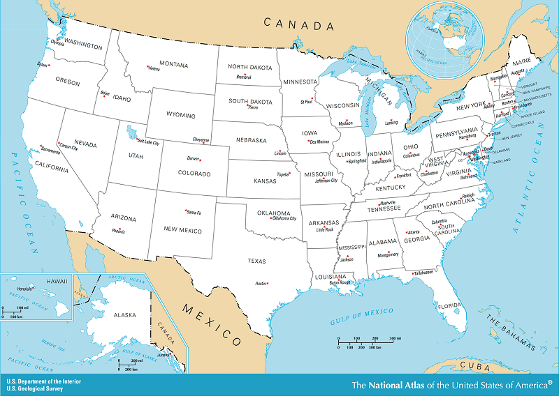
QUESTIONS - Examine the maps and answer the questions. Map of the 50 United States
Which country is north of New York state?
Which three states are directly east of New York state?
Which two states are directly south of New York state?
Which state and lake are directly north of Ohio?
Which two states are directly east of Ohio?
Which state is directly west of Ohio?
Which state is directly north of Iowa?
Which state is directly south of Iowa?
Which state is directly south of Virginia?
Which state is directly north of Louisiana?
Which state is directly east of Louisiana?
Which state is directly west of Louisiana?
Which state is directly south of Kentucky?
Which large island is just south of Florida?
Which gulf is just south of the United States?
Which states border the Pacific Ocean?
Which states border the Gulf of Mexico?
List five states that border the Atlantic Ocean.
List five states that are east of the Mississippi River.
List five states that are west of the Mississippi River.
Which river is just south of Ohio?
Which river starts in Minnesota and empties into the Gulf of Mexico?
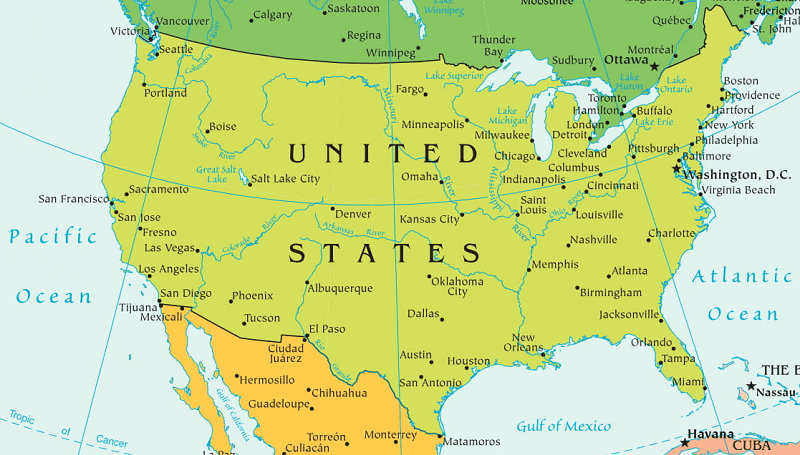
ANSWERS Select United States Lakes and Rivers
Canada is north of New York state.
Vermont, Massachusetts, and Connecticut are directly east of New York state.
Pennsylvania and New Jersey are directly south of New York state.
Michigan and Lake Erie are directly north of Ohio.
Pennsylvania and West Virginia directly are east of Ohio.
Indiana is directly west of Ohio.
Minnesota is directly north of Iowa.
Missouri is directly south of Iowa.
North Carolina is directly south of Virginia.
Arkansas is directly north of Louisiana.
Mississippi is directly east of Louisiana.
Texas is directly west of Louisiana.
Tennessee is directly south of Kentucky.
Cuba is just south of Florida.
The Gulf of Mexico is just south of the United States.
Washington, Oregon, and California border the Pacific Ocean.
Texas, Louisiana, Mississippi, Alabama, and Georgia border the Gulf of Mexico.
Maine, New Hampshire, Massachusetts, Rhode Island, Connecticut, New York, New Jersey, Delaware, Maryland, Virginia, North Carolina, South Carolina, Georgia, and Florida border the Atlantic Ocean.
States east of the Mississippi River include Mississippi, Alabama, Georgia, Florida, Tennessee, Kentucky, Illinois, Indiana, Ohio, Wisconsin, Michigan, West Virginia, South Carolina, North Carolina, Virginia, Maryland, Delaware, Pennsylvania, New Jersey, New York, Connecticut, Rhode Island, Vermont, New Hampshire, and Maine.
States west of the Mississippi River include Iowa, Missouri, Arkansas, Louisiana, Texas, Oklahoma, Kansas, Nebraska, South Dakota, North Dakota, Montana, Wyoming, Colorado, New Mexico, Arizona, Utah, Idaho, California, Nevada, Oregon, Washington, Alaska, and Hawaii.
The Ohio River is just south of Ohio.
The Mississippi River starts in Minnesota and empties into the Gulf of Mexico.
Notebook Work: Draw or color and label the following on the map of the continental United States: Pacific Ocean, Atlantic Ocean, Gulf of Mexico, Canada, Mexico, Vermont, Pennsylvania, Michigan, Indiana, Minnesota, Missouri, North Carolina, Mississippi, Arkansas, Tennessee, Washington, Oregon, Louisiana, Alabama, and Georgia.
 First Lessons in World Geography
World Geography
First Lessons in World Geography
World Geography


 About
About Curriculum
 Navigation